
In the last two decades, Charlotte’s population has grown exponentially, which has resulted in increased pollution, gentrification, and urban sprawl. As the city expanded physically, large portions of the forest, agricultural land, and other forms of natural green space have been lost to development. Within the city’s limits, urban green spaces, like parks and greenways, have been built in areas that disproportionately benefit wealthy and white neighborhoods. Additionally, the green spaces that do exist in marginalized communities are typically smaller, more polluted, less safe, and less well-maintained. As a result of disparities in access to green spaces, many marginalized communities are left without the benefits of outdoor recreation. GreenCLT seeks to embolden the Charlotte community to speak out about the destruction of natural green spaces and to demand equitable access to urban green spaces. Through working with local environmentalists this project will help advocate the need for increased protections for local green spaces and equitable management of the city’s parks.
GREENCLT WILL…

- Investigate Charlotte’s History of Environmental Racism
(use the redlining map shown above)
- Demand the Preservation of Existing Underdeveloped Land in Mecklenburg County
(outdoor wetland stock image)
- Emphasize the Need for Equitable Access to Green Space
(Diverse individuals enjoying the outdoors stock image[1] )
Urbanization in Charlotte
Urbanization, or the process of an area becoming more urban, has been a defining characteristic of the Charlotte area for the past two decades. In 2016, the Charlotte Observer reported that between April 2010 and July 2015, approximately 109 people per day moved to the Charlotte Metropolitan Area, which encompasses 3,198 square miles of surrounding towns, cities, and counties. Approximately half of those people moved into Charlotte proper, which in 2022 measured 312 square miles. Charlotte has experienced a population boom over the last two decades and the city is likely to continue to grow. The 2020 Census reports that there are 874,579 residents within the city limits and estimates that by 2022, 2.8 million people will reside in Charlotte Metropolitan Area. These statistics represent a 51% increase in the city’s population between 2000 and 2020. This population boom has led to several problems for the city, including skyrocketing land value, an affordable housing crisis, and the disappearance of the vast majority of undeveloped land. All of these factors have contributed to decreased green space in the Charlotte Metropolitan Area. For the purpose of this project, we define green space as land or bodies of water, both urban and rural, that possess grass, forest, or other forms of vegetation. Green space can be used for outdoor recreation and/or a space that provides aesthetic value to an area and/or habitat for wildlife.
Urban Sprawl In Charlotte

Charlotte’s population is not the only thing that has expanded in recent years; the land that the city occupies has also increased. In 1950, Charlotte occupied a mere 50 square miles but by 1970 the city grew to 76 square miles. Between 2001 and 2022, Charlotte grew by approximately 70 square miles. The 2020 census reports that Charlotte encompasses 308.29 square miles (currently 312 square miles). This is called urban sprawl, a term used to describe the outward geographic expansion of a city. Charlotte is unlike other major cities in the United States in that the land outside of the city is usable for urban development. Though cities like Boston or New York have a larger population than Charlotte, they have less available land to annex. Given the increasing population and the available land, Charlotte could expand for many more miles. The effects of urban sprawl include increased traffic congestion, pollution, and gentrification, which can be detrimental to the health and well-being of urban residents. Urban sprawl can also reduce the amount of available green space as development claims large tracts of forest and agricultural land. This is especially true for poor and minority populations, who are oftentimes displaced from their homes, and therefore their access to green spaces, when the cost of living becomes unaffordable.
The History of Environmental Racism in Charlotte
Red Lining: Racial Discrimination in the Housing Market
To explain the impact of race and class-based discrimination on green spaces we must first explain the history of environmental racism in Charlotte. This map is a product of the Home Owners’ Loan Corporation and the Division of Research & Statistics’ 1935 survey of Charlotte, which rated local neighborhoods based on their perceived credit risk for investors. This is called redlining, a discriminatory investment practice that devalues and withholds services to impoverished and/or majority POC (people of color) areas. Many Black neighborhoods, like Charlotte’s Second Ward, were colored in red to indicate to investors that there was a high risk of losing money on real estate in those areas. The majority of white neighborhoods, like Myers Park, Eastover, and the Olmstead portion of Dilworth, were colored green, to indicate low credit risk and high returns for investors. Race discrimination in the housing market meant that Black neighborhoods were continually devalued. Black residents lost out on the improvements and economic benefits that real estate investment provided for majority-white neighborhoods. The effects of these racist policies are present today: in 2017 the same areas that were deemed high risk in this 1935 survey still have the lowest rates of home ownership in Mecklenburg County.


These “Area Descriptions” are from the Home Owners’ Loan Corporation and the Division of Research & Statistics’ 1935 survey of Charlotte, NC. The image on the left (area A-3 on the above map) depicts the area description from a wealthy white neighborhood, while the image on the right (area D-3 on the above map) depicts the area description from a poor and majority Black neighborhood.
What is Environmental Racism?
Pollution in Black Neighborhoods Low-income and minority neighborhoods in Charlotte face higher rates of pollution, which contributes to unsafe green spaces and health issues. In Charlotte, segregation laws and redlining intentionally pushed Black residents into the West side of the city, often close to industrial polluters, such as factories, railroads, and highway systems. These industries released noxious emissions and leaked harmful chemicals into the soil, air, and water surrounding majority Black neighborhoods. The environmental hazards that these practices created caused serious health issues for residents, including many different types of cancer, asthma, and other diseases. It also undoubtedly polluted the green spaces that Black Charlotteans used for utility and recreation

Historic West End
The Historic West End neighborhood is just one example of a majority of Black neighborhoods in Charlotte that were subject to increased pollution exposure. Urban planners used zoning policies to designate where industries could build factories and organize construction sites. West End was targeted for these industrial zoning ordinances, which put industrial polluters directly next to Black communities. Additionally, when highway systems were built in Charlotte[1] they were concentrated on the West side, right next to Black neighborhoods like West End. This meant that Black residents breathed in more air pollution from cars and factories than White residents. The consistent disenfranchisement of Black communities in Charlotte, which had less political power and wealth than most white communities, meant that Black people bore the burden of negative health effects as well as decreased property values. All of these factors exacerbated cycles of poverty and reduced access to healthy and safe outdoor recreation.

Inequality And Access To Green Spaces
Environmental racism directly impacts a person’s access to green spaces. Charlotte’s City Government has invested large sums of money into creating urban green spaces. However, these efforts have historically concentrated on predominantly wealthy and white areas. Comparing green spaces in wealthy and mostly white neighborhoods to those in low-income and majority Black and POC neighborhoods exemplifies this issue.


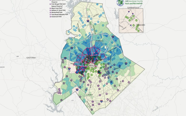
This map displays 203 of the public parks in Charlotte. Courtesy of the Mecklenburg County Park & Recreation Department.
The central region of the city hosts 68 of the city’s 203 parks, including many in both the red and green section of the 1935 Home Owners’ Loan Corporation’s redlining map. Though the Charlotte/Mecklenburg Quality of Life Explorer[1] reports that close to 100% of people in this area have access to spaces for outdoor recreation, this is not entirely true. Wealthy disparities, which are closely connected to race, often determine the quality, size, and number of parks in different neighborhoods.
Race and Urban Park Quality in Central Charlotte
This map[1] combines the location of urban parks in Charlotte with the distribution of Black residents. Areas that have a higher concentration of Black residents are depicted in dark blue and are outlined in red, while lower concentrations are depicted in light green and not outlined. In the central park region, there are approximately 32 parks in or bordering majority-Black neighborhoods and 36 parks in majority-white neighborhoods. The parks in Black neighborhoods have an average size of 10.9 acres, while the parks in white neighborhoods have an average size of 12.1 acres. Though the disparity in average size is relatively small, there is a greater disparity in the quality and condition of the parks between white and Black neighborhoods.
In 2021, the Mecklenburg Park and Recreation Commission found that 50 parks across the county were in poor condition. Commissioners rated them based on the condition of the park’s equipment, recreation options, cleanliness, and accessibility. Two parks in majority Black neighborhoods in central Charlotte received an ‘F’ grade, while nine parks received a ‘D’ grade. This means that 34% of parks in Black neighborhoods in central Charlotte were in poor condition. Comparatively, none of the parks in majority-white neighborhoods in central Charlotte received an ‘F’ grade, and only seven parks, or 19%, received a ‘D’ grade. This indicates that race plays a major role in the size, quality, and number of green spaces available to Charlotte’s most urban residents.
(Image of the greenway)
Wealth and Access to Green Space
Wealth is one of the largest factors in determining one’s access to quality green space. There is no better example of this than the disparities between the green spaces in central Charlotte’s wealthiest and poorest neighborhoods. The following analysis compares Freedom Park, which borders two of Charlotte’s wealthiest neighborhoods, and Wingate Park, which is situated in one of the poorest and most crime-riddled neighborhoods in the city.
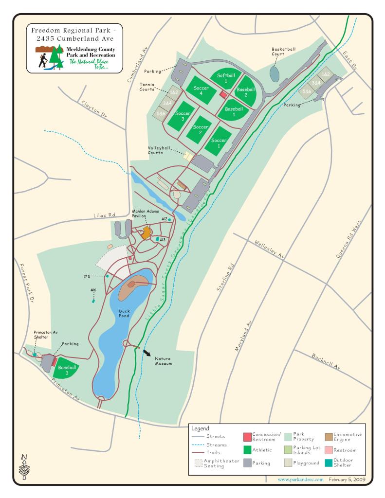
Freedom Park
Myers Park and Dilworth neighborhoods are remarkable for their historic architecture and high cost of living as well as their access to safe and clean green spaces. The majority of Myers Park and Dilworth residents are white, at 83.2%, while only a small number are Black, at 5%. Additionally, Myers Park and Dilworth residents make on average between 48% to 179% more income than the average Mecklenburg resident, with an average household income of $193,750 and $102,622 respectively. These two neighborhoods are also situated next to prime urban green spaces. Not only do residents have 10% more tree canopy than most other Mecklenburg residents, but they also have direct access to Charlotte’s largest urban park. At 98 acres, Freedom Park is far larger than all of the other parks in central Charlotte. In addition to its size, parkgoers can expect to find a host of amenities, including four baseball fields, twelve tennis courts, four soccer fields, a basketball court, two sand volleyball courts, two playgrounds, a lake and fountain, five outdoor shelters, numerous trails and sidewalks, sprawling lawns, a pavilion for performances, and ample space for outdoor recreation.
Reid Park and Community Tour
Irwin Creek and the Irwin Creek Greenway contribute a significant amount of green space and environmental history to Charlotte’s Reid Park community. Reid Park, like many other historically African American communities, faces issues such as pollution and exclusion from the environmental protections granted to majority-white neighborhoods.

In 1987, the Reid Park Neighborhood Association received a $5,300 grant from the Charles Stewart Mott Foundation. With the money, the organization commissioned two blue granite signs on brick piers to welcome visitors into the neighborhood. The inscription reads, “Welcome to Reid Park,” as well as “1935,” which is when the founder, Ross Reid, constructed the first house on the land. Unfortunately, the sign on Amay James Avenue no longer stands, though the one on Reid Avenue still stands.

This tributary and Irwin Creek overall have deep connections with the Reid Park community.[1] Before the neighborhood was annexed by the city of Charlotte in 1960, residents relied on the creek for drinking, bathing, and cooking water. There is a particular spring within the tributary that would produce clean water for the residents to use. Other uses for the creek included laundry and fishing. However, the tributary was not always beneficial. The creek could flood homes, become odorized, and be contaminated with sewage. Today, nature trails connect different parts of the neighborhood to the tributary.

The Irwin Creek Greenway runs through West Charlotte, running through Wesley Heights down towards Revolution Park. Although the greenway does not extend to Reid Park, its existence is still noteworthy. Irwin Creek runs along the southern end of Reid Park, surrounded by undeveloped land. Since the 1990s, Reid Park residents and community organizations, such as the West Boulevard Neighborhood Coalition, have been actively trying to get Reid Park connected to the main greenway. If completed, it would serve as a way to connect neighborhoods along the West Boulevard corridor. It would also work to prevent further pollution of the creek, as a developed greenway could deter illegal dumping.

This neighborhood park opened in 2015, after almost twenty-five years of waiting. Talks of a park began in 1991, and the initial plans centered around reviving the Amay Jame Park behind the Amay James Recreation Center. In 2013, a UNC Charlotte graduate student, Dylan McKnight, designed the park, working with Reid Park residents to ensure that it would fit their needs. The park itself has a basketball court, park shelter, community garden plots, picnic tables, and a variety of public art. Nature trails run along the Irwin Creek tributary in the center of the neighborhood, thus connecting the park with the outer parts of the neighborhood.

Although this school is currently Niner University Elementary, it was originally Amay James Elementary when it was first built in 1959. It served the African American communities along West Boulevard, and the school survived the backlash against desegregation in the 1960s. In 1992, the school transformed into Amay James Montessori, the first public Montessori in the state. It became an extremely popular magnet school, so in 2001, the program moved to Park Road Montessori to accommodate more students. After becoming a Pre-K center, the school then became home to Niner University Elementary, which is a UNC Charlotte-affiliated school meant to serve high-needs, low-income students.

In 1994, Reid Park Elementary opened its doors. As a magnet school, it offered a French immersion program for K-1 students, while older students could participate in its international baccalaureate (IB) program. It rests behind the former Amay James Elementary and is known today as Reid Park Academy. It is a Title I school, meaning that it has a high concentration of students from low-income families. The school receives federal funding to help ensure its students receive a high-quality education.

First built as the Amay James Community Center in 1977, this building originally rested on 40 acres of land. The main recreation center includes a gym, an auditorium with 350 seats, offices, game rooms, and arts-and-crafts spaces. The adjacent building used to be a resource center for health, financial, and employment counseling. It connects to nature trails that back up against Irwin Creek. Since it closed in 2008, the buildings have been undergoing renovations and are expected to reopen fall of 2022.

As part of a KaBOOM Community-Built Playspace Grant, the Charlotte Action Research Project (CHARP) worked together with the Reid Park community and other volunteers to construct this playground off of Amay James Avenue. It is located just down the street from Reid Neighborhood Park.

The Amay James Presbyterian Church was the first African American church in the county to join the Mecklenburg Presbytery. Although the congregation was officially formed in 1942 when it successfully petitioned the Mecklenburg Presbytery, its roots can be traced back to 1922 and one Amay Martin James. At the request of a friend, James laid the foundations for a Sunday School that would cater to African American children in what is now Reid Park. She would be the lead instructor for almost twenty years. Although the church eventually closed in 1986 due to a lack of funds and low membership rates, the legacy of the church and its founder can be seen throughout Reid Park. The physical church is now the location of the Christian Mission Baptist Church.

Although this church is not technically located in Reid Park, it is still important to the neighborhood’s history and community. Elijah Ross, the brother of Ross Reid, was the preacher at New Shiloh Baptist Church. According to Laura Rankin and Curley Hall, two former residents of Reid Park, the New Shiloh Baptist Church would perform baptisms in the tributary that would run through Reid Park. Several residents of Reid Park also were a part of the congregation.

Disappearing Tree Canopy
Another problem that contributes to the degradation of green spaces in Charlotte is the city’s disappearing tree canopy. Charlotte was once known for its shady tree cover, but now development threatens the city’s tree canopy more than ever. Not only are tree-covered cities more aesthetically pleasing, but they also offer respite from the sun; which is much needed during the hot southern summer. Environmental racism is one of the factors that contribute to how heat is experienced in urban areas. In fact, cities with higher populations of Black people are more likely to experience extreme heat. This is also true for white and Black Charlotteans. North and West Charlotte, which has a high concentration of Black residents, has significantly less tree coverage than South Charlotte, which is predominately white. This means that Black residents experience more heat when participating in outdoor recreation.
Natural Green Space And Undeveloped Land In Mecklenburg County
Undeveloped Land in Mecklenburg County is Dwindling
Limited access to man-made green spaces is only one part of the problem; urban sprawl also contributes to the eradication of undeveloped land and natural green spaces, which provides food, recreation, water, and wildlife habitat. Environment North Carolina reported that between 1999 and 2009 the Charlotte area lost 25%, or 270,000 acres, of its total cropland and forest land. The environmentalist organization also predicted that the Charlotte area will continue to lose large portions of woodlands, farmlands, and undeveloped land to development. Developers have already eradicated much of the natural green space in the Charlotte area, but there are still green spaces on the city’s periphery and in the greater Charlotte Metropolitan area. Today only 16.1 percent of the land, or 53,440 acres, in Mecklenburg County is undeveloped, which represents a 2.2 percent decrease since 2011. A large portion of the undeveloped land lies to the west of the Charlotte Douglas International Airport and is set to become the River District mixed-use project. Unless the city or county government prevents development in rural and semi-rural areas, urbanization will claim the remaining natural green spaces in Charlotte and deprive its residents of their benefits.
Health Benefits of Outdoor Recreation
The loss of green space is not just important because marginalized groups in Charlotte do not have equal access to parks and other green spaces, but also because there are many proven mental and physical benefits to spending time in nature. Green spaces are natural inhibitors of exercise, socialization, and fun. Parks facilitate playing group sports, such as tennis, volleyball, basketball, and soccer, and provide spaces for other outdoor exercises, such as walking and running. Park playgrounds also give children the opportunity to exercise with peers in a social environment. Green spaces have the ability to bring communities together in a positive and healthy manner.
People who participate in outdoor recreation have better physical and mental health. Outdoor exercise is related to a wide array of health benefits, including “lower risks of type 2 diabetes, cancer, stroke, hypertension, cardiovascular disease, and premature mortality.” Aside from physical benefits, green space exposure also leads to improved mental health. People who spend time in green spaces reported improved mental health, mood, and self-esteem as well as lower rates of stress than those who do not regularly spend time outdoors. It is a form of environmental racism that some Charlotte communities have unadulterated access to these benefits and others do not.
Charlotte’s Plan for the Future
Fortunately, Charlotte’s local government has recognized that the city’s green spaces need work. For the past several years Charlotte has scored low on the Trust for Public Land’s ParkScore index, which ranks America’s 100 largest cities on the quality and accessibility of their green spaces. In 2021, Charlotte was 91st on the list, but in 2022 the city jumped up to the 83rd spot. However, compared to other cities in North Carolina, Charlotte is still lacking. Durham (82), Winston-Salem (80), Greensboro (76), and Raleigh (50), all have better scores than Charlotte. The good news is that the city is considering how it can improve green spaces to provide a better quality of life to its citizens. In the summer of 2022, the Mecklenburg Parks and Recreation Department announced that it has allotted $50 million dollars to spend on competing with developers for land as well as funds for repairing parks and greenways that are in poor condition. The city’s 2040 plan also includes a dedicated plan of action to improve existing parks and preserve natural areas. Even though these initiatives are promising, the city must recognize the current systems of inequality that affect green spaces. Specifically, these plans must include initiatives to reduce pollution and increase the quality of green spaces in North and West Charlotte. Additionally, the dwindling amount of undeveloped land is a large threat to nature and wildlife as well as access to outdoor recreation. GreenCLT demands that green spaces, both natural and man-made, be protected in perpetuity for the health and betterment of all people in Charlotte.